 GSNI Data Catalogue
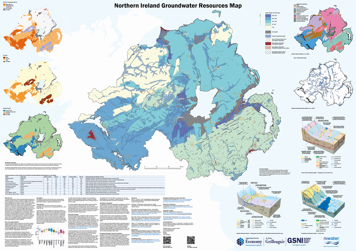
Northern Ireland Groundwater Resources Map 1:250,000 (2026)
The Northern Ireland Groundwater Resources Map was produced by Geological Survey of Northern Ireland with funding from Northern Ireland Water.
This map was produced to show where groundwater resources are available in Northern Ireland. It is based on aquifer yield data held by the Geological Survey of Northern Ireland (GSNI) and the new aquifer classifications presented in Northern Ireland’s Groundwater Environment (Wilson et al., 2023) ( https://gsni-data.bgs.ac.uk/geonetwork/srv/eng/catalog.search#/metadata/246fc03f-44aa-4178-b145-a0745aabd52a). While the map provides an estimate of the potential yields that could be abstracted by a single borehole, it is important to recognize groundwater as a valuable resource which should be used and managed sustainably as it also plays an important role in supporting surface water ecosystems. The potential for any new abstraction to impact either existing abstractions and/or groundwater flows to Groundwater Dependent Terrestrial Ecosystems (GWDTE’s) should be considered when planning for a new abstraction and will be an important aspect of the abstraction licence approval process. Therefore, this map also shows current licenced groundwater abstractions, groundwater bodies in poor quantitative status as classified by the 2021 Groundwater Directive, as well as GWDTEs.
The Bedrock and Superficial Deposits Aquifers of Northern Ireland 1:250,000 (2023) ( https://gsni-data.bgs.ac.uk/geonetwork/srv/eng/catalog.search#/metadata/eeee2244-953d-4b81-8124-9e1ce602bf2e) provides the data that is presented in the maps and tables.
The aquifer summary statistics have been derived from the Northern Ireland Groundwater Data Repository. This is a database of over 2000 boreholes and springs. An index can be viewed at https://mapapps2.bgs.ac.uk/gsni_geoindex/home.html
These attributes can be used to create bespoke groundwater maps, such as those shown on this map, relevant to the application they are being used for.
Simple
- Date (Creation)
- 2026-03-19
- Citation identifier
- http://gsni-data.bgs.ac.uk/geonetwork/srv/resources/9a5354fc-8473-4d0c-880c-b52e65aa7b51
- Point of contact
-
Organisation name Individual name Electronic mail address Role Geological Survey of Northern Ireland
Publisher
- Maintenance and update frequency
- Not planned
- Metadata author
-
Organisation name Individual name Electronic mail address Role Geological Survey of Northern Ireland
Custodian
-
GEMET - INSPIRE themes, version 1.0
-
-
Geology
-
- Keywords
-
-
Groundwater
-
Aquifer
-
Hydrogeology
-
- Access constraints
- Other restrictions
- Other constraints
- INSPIRE: no limitations
- Use constraints
- Other restrictions
- Other constraints
- Available under the Open Government Licence: https://www.nationalarchives.gov.uk/doc/open-government-licence/version/3/ We request that you acknowledge that the resource contains Geological Survey of Northern Ireland materials provided under the Open Government Licence.
- Spatial representation type
- Vector
- Denominator
- 250000
- Language
- English
- Character set
- UTF8
- Topic category
-
- Geoscientific information
- Code
- NIR
))
- Begin date
- 2000-04-01
- End date
- 2023-03-31
- Unique resource identifier
- EPSG:29902
- Distribution format
-
Name Version PDF
1.6
- OnLine resource
-
Protocol Linkage Name WWW:DOWNLOAD-1.0-http--download https://gsni-data.bgs.ac.uk/geonetwork/srv/api/records/9a5354fc-8473-4d0c-880c-b52e65aa7b51/attachments/NorthernIrelandGroundwaterResources.pdf Northern Ireland Groundwater Resources Map
- Hierarchy level
- Dataset
Conformance result
- Statement
-
The data from the Bedrock and Superficial Deposits Aquifers of Northern Ireland 1:250,000 (2023) dataset are presented in a PDF format, with supporting tables and figures to provide a summary of groundwater potential in Northern Ireland.
Metadata
- File identifier
- 9a5354fc-8473-4d0c-880c-b52e65aa7b51 XML
- Metadata language
- English
- Hierarchy level
- Dataset
- Date stamp
- 2026-03-19T09:25:35.443807Z
- Metadata standard name
-
ISO 19115:2003/19139
- Metadata standard version
-
1.0
- Metadata author
-
Organisation name Individual name Electronic mail address Role Geological Survey of Northern Ireland
Point of contact
)))