 GSNI Data Catalogue
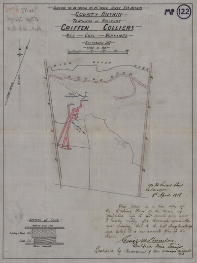
Griffin Colliery (M3/482) [MP122]
A raster scan of Griffin Colliery (M3/482) [MP122]. Commodity: Coal. Scanned from the Geological Survey of Northern Ireland archives.
Simple
- Date (Publication)
- 2022-01-01
- Date (Revision)
- 2022-01-01
- Citation identifier
- b3879612-9846-4e11-98c1-53a884897ae5
- Status
- Completed
- Point of contact
-
Organisation name Individual name Electronic mail address Role Geological Survey of Northern Ireland
Enquiries
Distributor
- Maintenance and update frequency
- Not planned
-
GEMET - INSPIRE themes, version 1.0
-
-
Geology
-
- Theme
-
-
Mine Plan
-
Resources
-
- Use limitation
-
Available to view under the Open Government Licence: https://www.nationalarchives.gov.uk/doc/open-government-licence/version/3/
- Use limitation
-
Please acknowledge that the resource contains Geological Survey of Northern Ireland materials provided under the Open Government Licence.
- Use limitation
-
Crown Copyright
- Access constraints
- Other restrictions
- Other constraints
- INSPIRE: no limitations
- Use constraints
- Other restrictions
- Other constraints
- INSPIRE: no conditions apply
- Spatial representation type
- Grid
- Denominator
- 1000
- Language
- English
- Character set
- UTF8
- Topic category
-
- Geoscientific information
))
- Extent type code
- Yes
- Geographic identifier
- NIR
- Unique resource identifier
- EPSG:29902
- Distribution format
-
Name Version GeoTIFF
unknown
JPEG2000
unknown
PDF
unknown
- OnLine resource
-
Protocol Linkage Name WWW:LINK-1.0-http--link | Web address (URL)
https://largeimages.bgs.ac.uk/iip/gsnimp.html?id=MP122 Scan of mine plan MP122
- Hierarchy level
- Dataset
Conformance result
- Statement
-
This map has been scanned at high resolution from an original copy held in the archives of the Geological Survey of Northern Ireland's Mine Abandonment Files. The original TIFF file has been georeferenced and subsequently converted to JPEG2000 and is available to view online.
Metadata
- File identifier
- b3879612-9846-4e11-98c1-53a884897ae5 XML
- Metadata language
- English
- Character set
- UTF8
- Parent identifier
-
Registered Collection of Mine Plans in Northern Ireland
baae8ba1-2d73-4dff-90fc-f52d426d1701
- Hierarchy level
- Dataset
- Date stamp
- 2023-02-08T08:17:14
- Metadata standard name
-
ISO 19115:2003/19139
- Metadata standard version
-
1.0
- Metadata author
-
Organisation name Individual name Electronic mail address Role Geological Survey of Northern Ireland
Enquiries
Point of contact
)))