 GSNI Data Catalogue
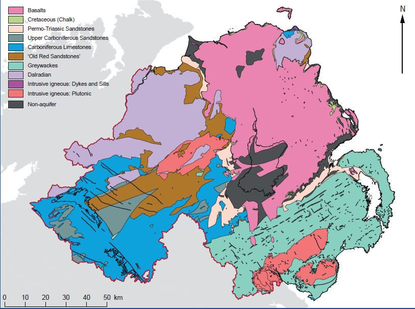
Bedrock and Superficial Deposits Aquifers of Northern Ireland 1:250,000 (2023)
The Bedrock and Superficial Deposits Aquifers of Northern Ireland show the extent of each of the 11 defined aquifers found in Northern Ireland. They are attributed with aquifer descriptions and include summary statistics of physical and chemical properties of each aquifer.
This data accompanies the ‘Northern Ireland’s Groundwater Environment’ book which can be accessed at https://nora.nerc.ac.uk/id/eprint/535562/. This provides information on how the aquifers were defined and delineated, aquifer conceptual models and explains the groundwater processes within each aquifer.
The GSNI 1:250,000 bedrock and superficial datasets ( https://gsni-data.bgs.ac.uk/geonetwork/srv/eng/catalog.search#/metadata/50f02373-cc6e-46f6-b3e2-f05be55b662a) provided the base mapping for these datasets.
The aquifer summary statistics have been derived from the Northern Ireland Groundwater Data Repository. This is a database of over 2000 boreholes and springs. An index can be viewed at https://mapapps2.bgs.ac.uk/gsni_geoindex/home.html. These attributes can be used to create bespoke groundwater maps relevant to the application they are being used for .
Simple
- Date (Creation)
- 2023-08-09
- Citation identifier
- http://gsni-data.bgs.ac.uk/geonetwork/srv/resources/eeee2244-953d-4b81-8124-9e1ce602bf2e
- Point of contact
-
Organisation name Individual name Electronic mail address Role Geological Survey of Northern Ireland
Publisher
- Maintenance and update frequency
- Not planned
- Metadata author
-
Organisation name Individual name Electronic mail address Role Geological Survey of Northern Ireland
Custodian
-
GEMET - INSPIRE themes, version 1.0
-
-
Geology
-
- Keywords
-
-
Groundwater
-
Aquifer
-
Hydrogeology
-
- Access constraints
- Other restrictions
- Other constraints
- INSPIRE: no limitations
- Use constraints
- Other restrictions
- Other constraints
- Available to view under the Open Government Licence: https://www.nationalarchives.gov.uk/doc/open-government-licence/version/3/ We request that you acknowledge that the resource contains Geological Survey of Northern Ireland materials provided under the Open Government Licence.
- Spatial representation type
- Vector
- Denominator
- 250000
- Language
- English
- Character set
- UTF8
- Topic category
-
- Geoscientific information
- Code
- NIR
))
- Begin date
- 2017-04-01
- End date
- 2023-03-31
- Unique resource identifier
- EPSG:29902
- Unique resource identifier
- EPSG:4258
- Unique resource identifier
- EPSG:3857
- Distribution format
-
Name Version OGC Geopackage
1.2.1
- OnLine resource
-
Protocol Linkage Name WWW:DOWNLOAD-1.0-http--download
https://gsni-data.bgs.ac.uk/geonetwork/srv/api/records/eeee2244-953d-4b81-8124-9e1ce602bf2e/attachments/NorthernIrelandsGroundwaterEnvironment.zip NorthernIrelandsGroundwaterEnvironment.zip
- Hierarchy level
- Dataset
Conformance result
- Statement
-
These two datasets are the Superficial Deposits and the Bedrock groundwater aquifers of Northern Ireland. They show the extent of each of the 11 defined aquifers found in Northern Ireland. They are attributed with aquifer descriptions and include summary statistics on the aquifer physical and chemical properties.
They accompany the ‘Northern Ireland’s Groundwater Environment’ book which can be accessed at https://nora.nerc.ac.uk/id/eprint/535562/. This provides information on how the aquifers were defined and delineated, aquifer conceptual models and explains the groundwater processes within each aquifer .
The GSNI 1:250,000 bedrock and superficial geology data provide the geometry from which these data have been generated for these datasets.
The aquifer summary statistics have been derived from the Northern Ireland Groundwater Data Repository. This is a database of over 2000 boreholes and springs. An index can be viewed at https://mapapps2.bgs.ac.uk/gsni_geoindex/home.html. These attributes can be used to create bespoke groundwater maps relevant to the application they are being used for.
All other aquifer description attributes have been derived using a combination of available information and expert judgement by BGS Hydrogeologists.
Metadata
- File identifier
- eeee2244-953d-4b81-8124-9e1ce602bf2e XML
- Metadata language
- English
- Hierarchy level
- Dataset
- Date stamp
- 2026-03-19T09:22:25.528945Z
- Metadata standard name
-
ISO 19115:2003/19139
- Metadata standard version
-
1.0
- Metadata author
-
Organisation name Individual name Electronic mail address Role Geological Survey of Northern Ireland
Point of contact
)))