Groundwater temperature profiles of Superficial, Dalradian and Carboniferous Limestones in the Derg and Blackwater Catchments
These data present monthly temperature profiles for nine boreholes located within the Derg (six) and Blackwater (three) catchments that are installed in three aquifers (Superficial (five), Dalradian (three) and Carboniferous Limestone (one)). These data was collected between 10th November 2020 and 17th August 2022. Data was collected hourly by Hobo level logger.
The spreadsheet presents data on the monitoring boreholes including Easting, Northing, Elevation, Groundwater Data Repository (GDR) number and depth of the top and bottom of the screened section. Time series temperature data is available for each borehole at one hour interval.
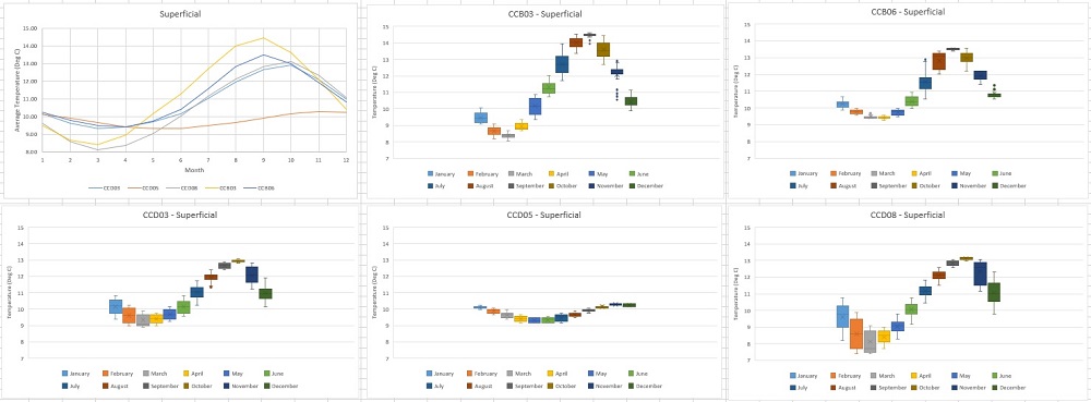
The data has been summarized and box and whisker plots of monthly temperatures for each individual borehole have been produced. Line plots have also been produced showing the average monthly temperature at each borehole grouped by aquifer (Superficial, Dalradian and Carboniferous Limestone).
These boreholes were installed as part of the CatchmentCARE project.
Simple
- Date (Creation)
- 2022-01-05
- Citation identifier
- https://gsni-data.bgs.ac.uk/geonetwork/srv/resources/2aae1abc-0126-46e7-ac8e-0e35d828d455
- Point of contact
-
Organisation name Individual name Electronic mail address Role Geological Survey of Northern Ireland
Publisher
- Maintenance and update frequency
- Irregular
- Metadata author
-
Organisation name Individual name Electronic mail address Role Geological Survey of Northern Ireland
Custodian
-
GEMET - INSPIRE themes, version 1.0
-
-
Geology
-
- Keywords
-
-
Hydrogeology
-
Groundwater
-
CatchmentCARE
-
- Access constraints
- Other restrictions
- Other constraints
- INSPIRE: no limitations
- Use constraints
- Other restrictions
- Other constraints
- Available to view under the Open Government Licence: https://www.nationalarchives.gov.uk/doc/open-government-licence/version/3/ We request that you acknowledge that the resource contains Geological Survey of Northern Ireland materials provided under the Open Government Licence.
- Spatial representation type
- Vector
- Denominator
- 10000
- Language
- English
- Character set
- UTF8
- Topic category
-
- Geoscientific information
- Code
- NIR
))
- Begin date
- 2020-11-10
- End date
- 2022-08-17
- Unique resource identifier
- EPSG:29902
- Distribution format
-
Name Version Microsoft Excel
- OnLine resource
-
Protocol Linkage Name WWW:DOWNLOAD-1.0-http--download
https://gsni-data.bgs.ac.uk/geonetwork/srv/api/records/2aae1abc-0126-46e7-ac8e-0e35d828d455/attachments/Temperature%20Profiles.xlsx Temperature Profiles in Excel format
- Hierarchy level
- Dataset
Conformance result
- Statement
-
Data was retrieved in a csv format from a Hobo level logger installed in each borehole. Data was then cleaned up removing any data points from the duration the the logger was removed from the borehole (ie. for downloading purposes). The excel pivot table function was used to obtain the average temperature experienced during each month. To produce box and whisker plots using the excel function each data point was assigned to a month and the data were then copied into their respective bins.
Metadata
- File identifier
- 2aae1abc-0126-46e7-ac8e-0e35d828d455 XML
- Metadata language
- English
- Hierarchy level
- Dataset
- Date stamp
- 2023-11-08T08:32:21
- Metadata standard name
-
ISO 19115:2003/19139
- Metadata standard version
-
1.0
- Metadata author
-
Organisation name Individual name Electronic mail address Role Geological Survey of Northern Ireland
Point of contact
Overviews
Spatial extent
)))
Provided by